
Early on Aug. 17, Hurricane Erin’s outer rainbands were “producing gusty winds and heavy rains across the Virgin Islands and Puerto Rico,” according to the National Hurricane Center.
Where will the hurricane hit? Will it hit the U.S.? Spaghetti models and other trackers and forecasts give a sense of the hurricane’s predicted path. According to Newsweek, recent spaghetti models show that the storm is “unlikely” to directly strike the East Coast of the U.S. That’s a change from earlier models that showed it might hit Florida, Newsweek noted.
ABC News concurred, writing, “The majority of meteorological modeling continues to keep Erin well off the East Coast of the U.S. by hundreds of miles.” However, hurricanes can shift, so nothing is certain. ABC published a spaghetti model showing the near miss, however.
Cyclocane also has a page of spaghetti models that show Erin tracking just off of the coast. See a live tracker for Hurricane Erin here.
Dangerous Riptides From Hurricane Erin Are Expected to Hit the U.S. East Coast
The National Hurricane Center is warning of dangerous rip tides on the U.S. eastern seaboard. ABC News says that could hit between Aug. 20 and 27.
The Outer Banks and “other parts of North Carolina could see waves of 8 to 12 feet,” ABC News reported, with parts of South Carolina and Virginia possibly “seeing waves reaching 6 feet next week.”
Latest early morning spaghetti models on Hurricane Erin. pic.twitter.com/oRcaNlnlTk
— PC Weather Boy (@PC_WeatherBoy) August 16, 2025
A tropical storm watch was in effect for the Turks and Caicos Islands at 2 a.m. on Aug. 17. You can see updated forecast information for Hurricane Erin on the National Hurricane Center’s page for the storm.
A map shows the areas of the United States’ East Coast in peril for rip tides. Other maps show the arrival time of tropical-storm-force winds. Other maps show wind-speed probabilities. A cone map shows the storm’s path.
The site Spaghetti Models.com also has a page with spaghetti models showing Hurricane Erin’s path.
National Hurricane Center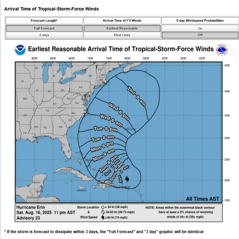
At 2 a.m., the storm was moving west-northwest near 14 miles per hour. The motion with a “decrease in forward speed” was expected to continue throughout the day, with the hurricane turning “to the north” on Monday Aug. 18 and Tuesday Aug. 19. That’s according to the National Hurricane Center.
The core of Erin “is expected to pass to the east of the Turks and Caicos Islands and the southeastern Bahamas” on the evening of Aug. 17 and into Aug. 18, the center wrote.
The hurricane was listed as a category 3 but was expected to fluctuate in intensity, the National Hurricane Center wrote.
Fresh Saturday 12z spaghetti models on Major Hurricane Erin on https://t.co/3cvwpvVJ22. Still confidence on that curve back N/NE, splitting the eastern US and Bermuda gap. Recent satellite showing some SW bumps but overall steering currents ahead favor these tracks. New NHC track… pic.twitter.com/aAMvmJccyz
— Mike’s Weather Page (@tropicalupdate) August 16, 2025
Swells from the hurricane are expected to spread to the East Coast of the U.S. and “Atlantic Canada” by the “early and middle portions of the week.” The swells “will likely cause life-threatening surf and rip currents,” the site noted.
“Despite being hundreds of miles offshore, Erin will likely bring dangerous rough surf, deadly rip currents, and possible erosion issues to beaches along the East Coast. The Outer Banks and Atlantic Canada could see some of the roughest beach conditions next week,” AccuWeather lead hurricane expert Alex DaSilva said in an advisory obtained by Newsweek.
Related: Milwaukee Flooding & Weather: Aug. 10 Forecast Shows ‘Dangerous’ Torrential Downpours
