
After forming Monday morning in the eastern Atlantic Ocean, Tropical Storm Erin is about to become the first hurricane of the 2025 Atlantic season. The storm spun to life just west of Africa’s Cabo Verde Islands. With 45-mph sustained winds and moving west through the so-called “main development region” of the Atlantic, Erin should gather strength in the coming days, projected to become the season’s first hurricane by Friday at 2 p.m. ET.
When will Erin become a hurricane, and how strong will it get?
Erin’s westward path will take most of the week to carry it into the western Atlantic, where the real drama could begin. Sea surface temperatures there are running warmer than average, though not at the record-breaking highs of 2023 and 2024. That should provide plenty of fuel for rapid intensification — the kind that can vault a storm from Category 1 to Category 3 or higher in less than 48 hours.
If Erin forms into a full-fledged hurricane, it’ll be a late debut for the Atlantic basin’s first hurricane. Historically, the inaugural one appears by August 11. So far, four named storms have formed — Andrea, Barry, Chantal, and Dexter — but none reached hurricane status. Compare that to last year, when by this date the Atlantic had already produced hurricanes Beryl and Debby, with Ernesto on the horizon. Still, the clock now tilts toward peak hurricane season, which runs mid-August to mid-October.
Where is Erin headed?
AccuWeather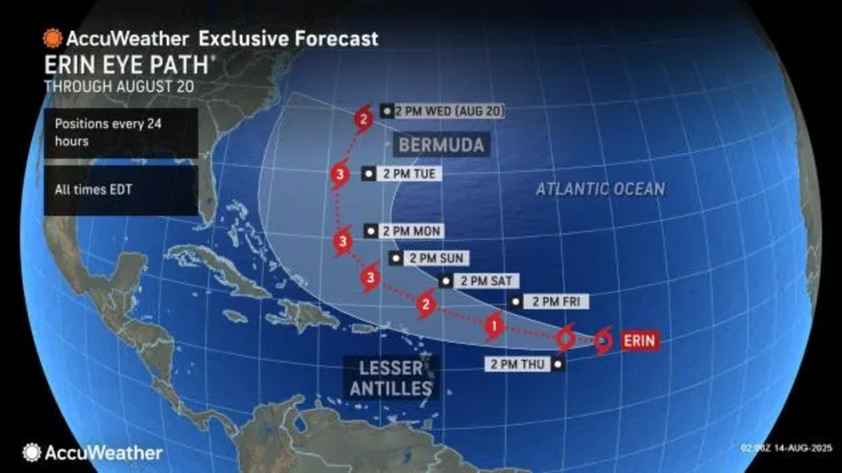
Whether Erin poses a serious threat to the Caribbean, Bermuda, or the U.S. mainland will depend on two variables: its eventual strength and the behavior of the Bermuda High, a semi-permanent area of high pressure located over Bermuda in summer and fall that steers many storm systems westward across the Atlantic. Most projections currently have it staying offshore, but that could change.
At the moment, Erin is expected to pass just north of the Leeward Islands, Virgin Islands and Puerto Rico, but heavy rain, tropical-storm force winds and dangerous rip currents are still be possible this weekend.
The National Hurricane Center notes that Erin could reach major hurricane status by Saturday if conditions line up. Two other areas of potential tropical development are also being monitored in the open Atlantic, both currently with low chances of formation.
What are experts saying about this year’s hurricane season?
The National Weather Service projects an above-normal 2025 season with 13 to 18 named storms expected to form, with five to nine evolving into hurricanes. Erin, if the models hold, looks set to open the hurricane ledger. The Pacific, by contrast, has already logged six hurricanes this year, including Henriette, now far north of Hawaii and posing no threat to land.
